City | People and Bike Counting On Streets
Pedestrian and Cyclist Counting on City Streets
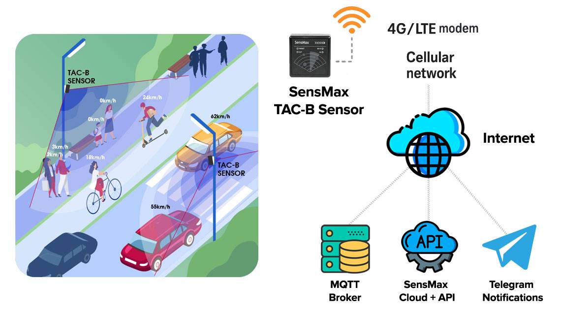
SensMax TAC-B 4G together with the SPS20 solar power system provides a reliable outdoor people counting solution for city streets, promenades, shared pedestrian and bicycle paths, and cycling routes. The radar-based system counts pedestrians, cyclists, and scooter riders in both directions and delivers reliable statistics for urban mobility monitoring, street design decisions, cyclist traffic analysis, and smart city planning.
The system uses 60 GHz mmWave radar technology instead of cameras, which means it does not record images or video and does not collect personal data. This makes the solution suitable for GDPR-compliant monitoring of public space usage in modern smart city environments.

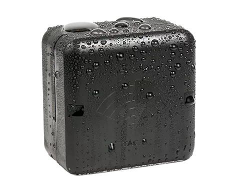
Radar people counting sensor with SPS20 solar power kit installed on a city street pole
Why Pedestrian and Cyclist Counting Matters
City streets, walking areas, and cycling lanes are essential parts of urban mobility. Understanding how many people walk, cycle, or use scooters on these routes helps municipalities evaluate how public space is used throughout the day, week, and season.
Reliable street mobility data allows planners to measure the impact of infrastructure changes, compare different streets or districts, and make evidence-based decisions about pedestrian zones, bicycle lanes, and traffic calming initiatives.
Pedestrian and cyclist counting helps cities to:
- plan sidewalks, cycling lanes, and pedestrian crossings
- compare usage of different streets and public spaces
- measure the impact of street redesign or mobility projects
- support sustainable transport and car-free initiatives
- prepare reports for urban mobility programs and funding applications
Radar People Counting Technology for City Streets
SensMax TAC-B 4G uses 60 GHz mmWave radar technology to detect moving objects within a defined detection zone. Unlike camera systems, the radar analyzes movement vectors and trajectories rather than visual images, allowing the system to count objects while maintaining complete anonymity.
The radar sensor detects pedestrians, bicycles, and scooters moving across configurable virtual counting lines. Direction detection allows separate counting of IN and OUT movements, providing reliable data on movement patterns along streets, promenades, and shared pedestrian and bicycle routes.
Because radar works independently of lighting conditions, the system operates reliably in rain, fog, snow, bright sunlight, and complete darkness.

Radar people counting sensor integrated into smart city street infrastructure
How It Works
The TAC-B radar sensor is typically mounted on a pole or street infrastructure element at approximately 2.5–3 m height above the monitored path. When pedestrians or cyclists move through the configured detection zone, the radar measures motion, determines direction, and records counting events.
Each sensor can monitor movement within up to a 10 m range and a field of view of up to 120°, covering approximately 100 m² depending on installation conditions. Configurable virtual counting lines support separate IN and OUT statistics for different traffic flows.
Collected data is stored locally and transmitted via the built-in 4G modem to the SensMax Cloud platform, where statistics become available for dashboards, reporting, and integration with urban mobility analysis tools.
Data, Analytics and Monitoring
All counting data is stored in the SensMax Cloud platform where cities and infrastructure operators can view hourly, daily, weekly, and seasonal traffic statistics. This makes it possible to identify peak traffic periods, compare usage between streets or districts, and evaluate the impact of urban mobility projects over time.
The system supports long-term public space monitoring and cyclist traffic analysis by making it easier to compare locations, detect recurring movement patterns, and measure before-and-after results of street redesigns, bicycle lane improvements, and pedestrian safety projects.
Integration with external systems is supported through API and MQTT, allowing data to be connected with smart city dashboards, GIS platforms, IoT systems, BI tools, and broader urban mobility analysis environments.
Installation
The TAC-B radar is typically installed on lamp posts, traffic light poles, or similar structures at approximately 2.5–3 m height with a clear view across the monitored street or path. Correct positioning is important to achieve stable detection across the required counting zone.
For locations without power infrastructure, the system can be combined with the SPS20 solar power kit, which includes a LiFePO4 battery and supports autonomous operation for up to 64–85 hours without sunlight. Because the sensor also includes a built-in 4G modem, no local internet connection is required.
This makes the solution suitable for deployment on almost any city pole without wiring or local IT infrastructure, which is especially useful for temporary counts, pilot projects, and distributed smart city installations.
Radar sensor installation for pedestrian and cyclist counting on a smart city street
Key Technical Advantages
- Radar-based pedestrian and cyclist counting without cameras
- GDPR-compliant anonymous detection for public space monitoring
- Suitable for streets, promenades, and shared pedestrian and bicycle paths
- Up to 10 m detection range with 120° field of view
- 4G connectivity without local internet infrastructure
- Optional SPS20 solar kit for off-grid installations
- LiFePO4 battery backup supporting up to 64–85 hours operation without sunlight
- Reliable outdoor operation in rain, fog, snow, and darkness
- API and MQTT integration for smart city and urban mobility platforms
Real-World Applications
- busy city streets and pedestrian corridors
- cycling lanes and shared pedestrian and bicycle paths
- river promenades and waterfront routes
- tourist streets and historic districts
- access routes to public transport stations
- urban plazas and public squares
- city mobility monitoring and smart city projects
Business Impact
Understanding pedestrian and bicycle traffic patterns helps cities evaluate how public space is used and where infrastructure investment is needed. Accurate usage data supports evidence-based planning of bicycle lanes, sidewalk improvements, and pedestrian safety projects instead of relying on manual observations or assumptions.
The collected statistics also help municipalities compare streets, prioritize crossings and mobility corridors, justify infrastructure budgets, and prepare reports for funding programs related to smart city, sustainability, and urban mobility development.
Example in Action
A city installs TAC-B radar sensors along a popular river promenade and on several nearby shared pedestrian and bicycle routes to measure movement patterns across different locations. After several weeks of monitoring, the collected data reveals clear weekday commuter peaks on the shared routes and much higher recreational activity on the promenade during weekends.
Based on these insights, the city prioritizes new bicycle lane expansion on the busiest commuter corridor, improves lighting along the most heavily used pedestrian sections, and uses the traffic data to support funding requests for the next phase of public space improvements.
FAQ
- What types of traffic does the radar detect?
The system detects pedestrians, cyclists, and scooter riders moving through the monitored detection zone. - Is the solution GDPR compliant?
Yes. The radar measures movement only and does not capture images, video, or personal identifiers. - Can the system work without local power?
Yes. With the SPS20 solar kit, the system can operate autonomously using solar energy. - Does the radar work at night or in bad weather?
Yes. Radar detection is not affected by lighting conditions and works in rain, fog, snow, and darkness. - Can the data be integrated into smart city platforms?
Yes. Data can be integrated through API or MQTT into GIS, IoT, BI, and smart city analytics systems. - What installation height is recommended?
Sensors are typically mounted at approximately 2.5–3 m above the monitored street or path.
Technical Details
| Feature | Details |
|---|---|
| Application | Pedestrian and cyclist counting on city streets, promenades, and shared paths |
| Technology | 60 GHz mmWave radar people counting sensor |
| Movement tracking | Direction-aware radar movement detection with virtual counting lines |
| Counting logic | Separate IN and OUT statistics for pedestrian and cyclist flows |
| Detection range | Up to 10 m |
| Detection angle | Up to 120° |
| Coverage area | Approximately 100 m² |
| Detected objects | Pedestrians, cyclists, scooters |
| Data cadence | Automatic cloud-based data collection with hourly, daily, weekly, and seasonal reporting |
| Connectivity | 4G / API / MQTT |
| Installation type | Pole, lamp post, traffic light pole, or similar street infrastructure |
| Mounting height | Approximately 2.5–3 m |
| Storage | Internal SD card backup for local data storage during communication loss |
| Power supply | SPS20 solar power kit with LiFePO4 battery |
| Backup autonomy | Up to 64–85 hours without sunlight |
| Operating conditions | Outdoor use in rain, fog, snow, bright sunlight, and darkness |
| Accuracy | Typically 95–98% depending on density and installation conditions |
| Maintenance | Low-maintenance operation with periodic visual inspection recommended |