Trails | People Counting on Walking and Cycling Trails
Outdoor People Counting on Walking and Cycling Trails
Walking and cycling trails are popular places for recreation, sport, and local mobility. People use these routes in the morning, after work, and during weekends. To keep trails safe, clean, and well maintained, city services and park managers need reliable trail visitor statistics. The SensMax TAC-B 4G radar together with the SPS20 solar power system provides a ready-to-deploy solution for outdoor people counting on walking and cycling trails without cameras, electricity, or fixed internet infrastructure.
The system counts pedestrians, cyclists, and scooter riders in both directions and delivers accurate statistics to the cloud in real time. These insights help municipalities and park managers monitor trail traffic, compare visitor statistics between locations, and understand how trails are used throughout the day, across seasons, and in different weather conditions.

Radar people counter with SPS20 solar power kit installed on a forest trail
Why People Counting on Trails Matters
Visitor statistics from walking and cycling trails help managers allocate resources based on real usage rather than assumptions. Reliable data allows better planning of trail maintenance, infrastructure improvements, and safety measures.
The data also helps compare weekday commuter use with weekend recreational use and identify where trail upgrades deliver the greatest impact. This is especially useful for green mobility planning, park management, and funding applications for sustainable infrastructure.
- Plan cleaning schedules according to actual visitor traffic.
- Place benches, lighting, and waste bins where trail use is highest.
- Monitor peak periods to improve safety and prevent overcrowding.
- Compare different trails to prioritize upgrades or expansions.
- Provide objective statistics for funding and sustainability programs.
People Counting Technology for Walking and Cycling Trails
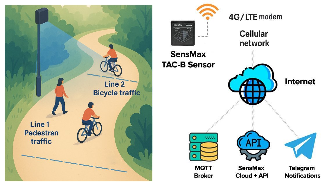
The TAC-B 4G radar sensor uses 60 GHz mmWave technology to detect moving objects on the trail. Instead of cameras, the radar measures motion vectors, movement direction, and speed. This allows the system to distinguish pedestrians from faster objects such as bicycles or scooters.
Virtual counting lines allow separate IN and OUT statistics, while speed analysis helps distinguish slower pedestrian traffic from faster cycling and scooter traffic. Because radar technology analyzes motion instead of images, the system does not record faces or personal data. All monitoring remains anonymous and fully GDPR-compliant, making it suitable for parks, natural areas, and public spaces.

Example of TAC-B radar placement with virtual counting lines across a trail
How It Works
The radar sensor is mounted on a pole, signpost, or lamp post approximately 2.5–3 m above the trail. When a pedestrian, cyclist, or scooter crosses the virtual counting line, the sensor detects the movement direction and registers the event.
Each device typically covers a detection range of up to 10 m with a 120° field of view, allowing monitoring of most walking and cycling trails with a single sensor. Count data is stored locally on the device and transmitted through the built-in 4G modem to the SensMax Cloud platform. If communication is interrupted, data remains stored locally and can be uploaded after the connection is restored.
Data, Analytics and Monitoring
All visitor statistics are available in the SensMax Cloud dashboard, where managers can review hourly, daily, weekly, and seasonal traffic data. This makes it possible to compare trail usage between locations, identify peak periods, and detect recurring patterns in commuter and recreational traffic.
The data supports before-and-after analysis of trail improvements, bicycle lane additions, lighting upgrades, and other mobility projects. It can also be used for long-term trail traffic monitoring, maintenance planning, and sustainability reporting.
Integration through API, MQTT, and webhooks makes it possible to combine trail statistics with weather data, environmental monitoring, GIS platforms, IoT systems, and smart city dashboards for broader urban and regional analysis.
System Architecture and Data Flow
For remote trail locations, the system combines on-device processing, mobile connectivity, solar power, and cloud reporting in one architecture.
- Sensor layer — TAC-B radar detects movement direction and speed and generates anonymous count events.
- Connectivity layer — built-in 4G modem sends encrypted data to the cloud.
- Power layer — SPS20 solar kit supplies continuous power using a solar panel and LiFePO4 battery.
- Cloud layer — SensMax Cloud stores data, creates reports, and provides integration interfaces.
Typical architecture: TAC-B radar → 4G network → SensMax Cloud → dashboards and smart city systems
Installation on Walking and Cycling Trails
The radar sensor can be installed on existing poles, signposts, or lamp posts along the trail. Correct positioning ensures a clear line of sight across the path and stable coverage of the required counting zone.
The SPS20 solar power system allows completely off-grid operation. The LiFePO4 battery provides approximately 64–85 hours of operation without sunlight depending on configuration and environmental conditions. This makes the solution suitable for remote forest trails, park routes, and rural cycling paths without grid power.
After mounting the hardware, installers configure virtual counting lines using a mobile device. Once set up, the system operates automatically and does not require regular on-site service.
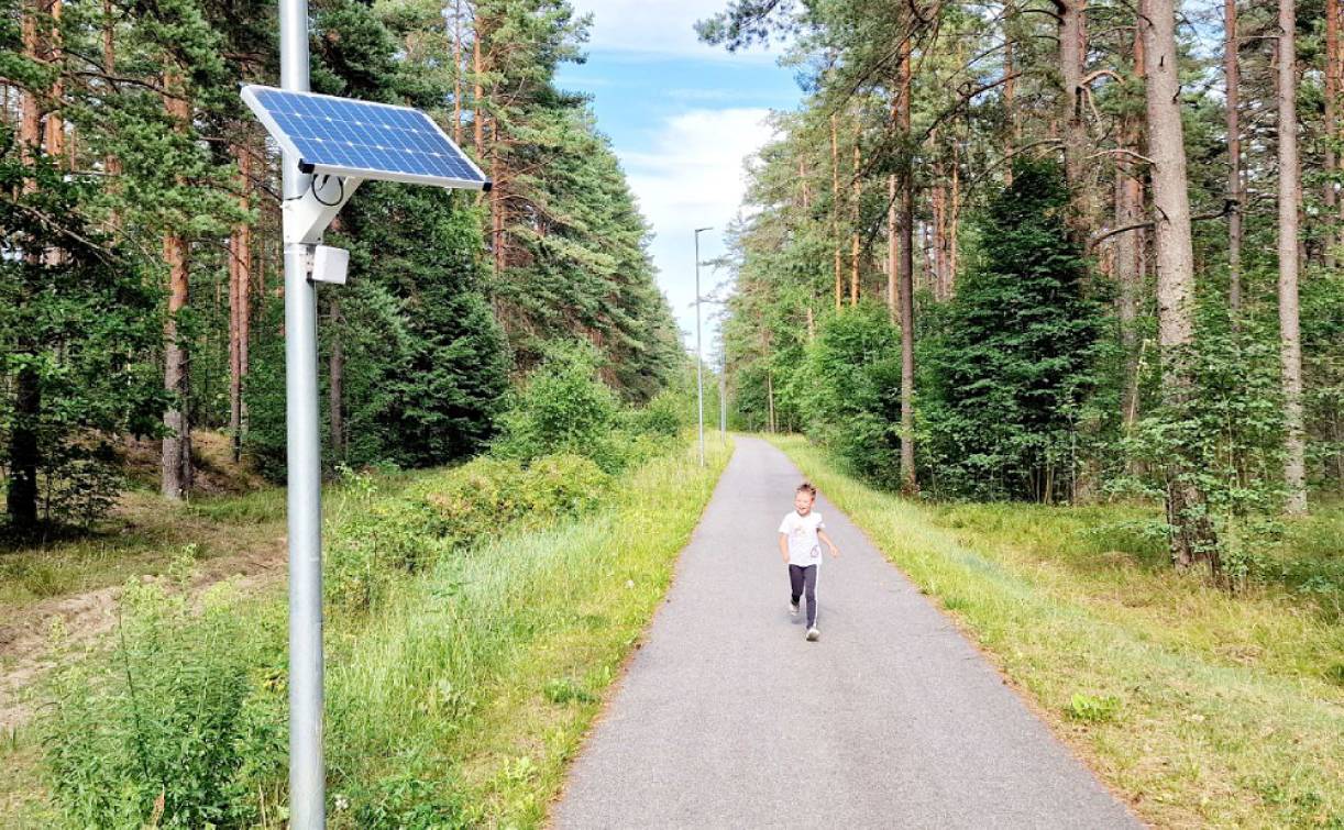
Solar-powered TAC-B radar installation on a walking and cycling trail
Key Technical Advantages
- Radar-based detection without cameras
- GDPR-compliant anonymous monitoring
- Off-grid operation using solar power
- Built-in 4G connectivity for remote trail locations
- Works in rain, fog, snow, sunlight, and darkness
- Separate counting of pedestrians and cyclists using motion characteristics
- Low-maintenance outdoor hardware with no lenses or moving parts
- Scalable for multiple trail locations
Real-World Applications
- forest and park walking trails
- cycling routes and commuter bike paths
- waterfront promenades and boardwalks
- national parks and protected natural areas
- greenways and eco-tourism trails
- rural walking routes and city park loops
- smart city green mobility projects
Business Impact
Trail traffic statistics help authorities manage infrastructure more efficiently. Reliable visitor numbers support maintenance planning, safety improvements, seasonal resource allocation, and budget prioritization for walking and cycling infrastructure.
The collected data can also support funding applications, sustainability reporting, and long-term decisions about trail expansion, lighting, cleaning schedules, and route improvements in both urban parks and natural areas.
Example in Action
A city installs radar counters on two popular forest trails and one commuter cycling route. Data shows that weekday bicycle traffic is concentrated on the commuter corridor, while weekend visitors primarily use the forest trails for recreation.
Based on these insights, the municipality adjusts maintenance schedules, adds lighting to the busiest sections, and uses the statistics to justify funding for an additional cycling path and trail surface improvements.
FAQ
- Where can the system be used?
Walking trails, cycling paths, waterfront promenades, national parks, and protected natural areas. - Does the sensor require electricity?
No. The SPS20 solar system provides autonomous off-grid power. - How long can it work without sunlight?
Typically 64–85 hours depending on configuration and environmental conditions. - How is data transmitted from remote trails to the cloud?
The sensor uses its built-in 4G modem to send encrypted count data directly to the SensMax Cloud. - Does weather affect performance?
Radar works reliably in rain, fog, snow, bright sunlight, and darkness. - What objects can be detected?
Pedestrians, cyclists, and scooter riders. - Does the system require maintenance?
Only occasional visual inspection is recommended.
Technical Details
| Application | Walking and cycling trail traffic monitoring and visitor statistics |
| Technology | 60 GHz mmWave radar people counting sensor |
| Movement tracking | Direction-aware radar detection with speed-based object separation |
| Counting logic | Virtual counting lines with separate IN and OUT statistics |
| Detection range | Up to 10 m |
| Detection angle | Up to 120° |
| Coverage area | Approx. 100 m² |
| Detected objects | Pedestrians, cyclists, scooters |
| Connectivity | 4G/LTE, API, MQTT, webhooks |
| Installation type | Pole, signpost, or lamp post mounting along walking and cycling trails |
| Mounting height | 2.5–3 m |
| Storage | Local data storage on device during communication interruptions |
| Power supply | SPS20 solar power system with LiFePO4 battery |
| Backup autonomy | Approx. 64–85 hours without sunlight |
| Operating conditions | Outdoor use, IP68 housing |
| Accuracy | Typically 95–98% depending on density and installation conditions |
| Maintenance | Low-maintenance operation with occasional visual inspection |